61 homes beside Langdon Ridge SSSI
A developer has applied to Basildon Borough Council for outline permission for up to 61 homes, at least half of them affordable, on about 2.45 hectares of Green Belt grassland north of Dry Street, Langdon Hills. The field adjoins Langdon Ridge Site of Special Scientific Interest. Protect Langdon has objected, on six grounds, with every point cited to the page.
Objection filed 10 October 2026. The Council has not yet decided the application. A matter of my own, as lead of Protect Langdon. Evidence analysis, not legal advice.
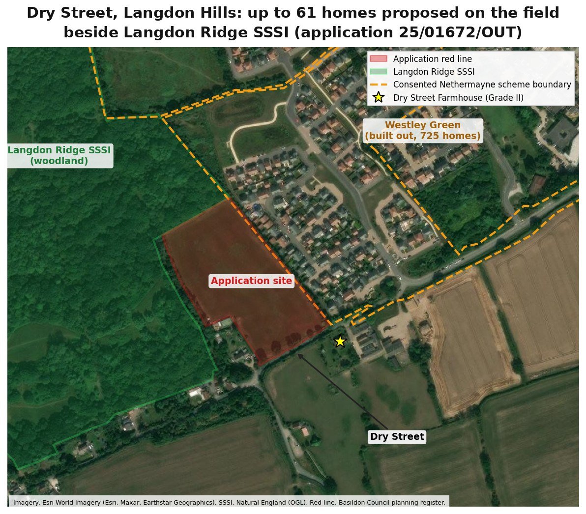
A Green Belt field on the edge of Langdon Ridge
The site is a grassland field north of Dry Street in Langdon Hills, on the south western edge of Basildon. It touches Langdon Ridge Site of Special Scientific Interest, a nationally designated site, and no point in it is more than about 160 m from the SSSI.
The land to the east is Land North of Dry Street, where outline permission for 725 homes was granted in December 2013, before the SSSI was notified.
The Council's draft Local Plan includes the field as a 2.5 hectare westward extension to Policy H20, Land North of Dry Street, which combines it with the 725 permitted homes.
- REFERENCE25/01672/OUT, Basildon Borough Council
- PROPOSALUp to 61 homes, at least 50 per cent affordable
- TYPEOutline, all matters reserved except access from Dry Street
- APPLICANTRO Land, with Bidwells as planning agent
- LANDAbout 2.45 ha of Green Belt grassland
From a 2013 permission to a decision this autumn
- 13 Dec 2013Outline permission granted for 725 homes on Land North of Dry Street (12/01080/OUT).
- 29 Jun 2018Langdon Ridge notified as a Site of Special Scientific Interest.
- 23 Dec 2025Application 25/01672/OUT for up to 61 homes on the field to the west received.
- 19 Feb 2026Application validated. Neighbours consulted from 24 February to 20 March 2026.
- 3 Mar 2026Essex Wildlife Trust objects to the application. Its objection does not appear on the planning register; the Trust re-submits it on 29 September.
- 21 Jul 2026The Government directs the Council on the preparation of its Local Plan.
- 28 Sep 2026Environmental Information Regulations requests sent to Basildon Council (two), Essex County Council and Natural England.
- 10 Oct 2026Protect Langdon files its objection, copied to the three ward councillors, the Leader of the Council and the Cabinet Member for Planning and Infrastructure, and sent to Natural England and Essex Wildlife Trust.
- 27 Oct 2026Extended decision date, agreed with the applicant. The decision is still pending.
Objection filed. The decision is pending
The statutory decision date passed in May. The Council and the applicant agreed to extend it to 27 October 2026, and that date has passed without a decision. When we filed on 10 October, 10 of 21 consultees had responded and none of their responses was published on the register. Our objection asks the Council to publish them, and to refer the application to the Planning Committee.
What happens next. The Council acknowledges the objection; the consultee responses, including Natural England's, should be published; the case officer writes the officer report; and the application is decided either by officers under delegated powers or by the Planning Committee. Replies to our information requests are due by 26 October.
- Go to planning.basildon.gov.uk, search for 25/01672/OUT and use Make a Comment, or email planning@basildon.gov.uk with 25/01672/OUT in the subject line, your name and postal address, and the word Objection.
- Write in your own words. Two or three sentences are enough, with anything you have seen yourself: muddy paths and trampled woodland in winter, water on Dry Street after rain, traffic on the lane.
- Ask for the application to be refused, and to be decided by the Planning Committee in public rather than by an officer.
- The formal consultation closed in April, but the Council can take account of comments received before it decides. Say: please take this into account before the decision.
Six grounds, and a field that cannot hold the scheme
Filed on 10 October 2026 by Protect Langdon, with Dr Jackie Lighten as its representative. It asks the Council to refuse the application. The grounds, in order of weight:
Langdon Ridge SSSI
The application does not assess recreational, pet, lighting or in-combination effects on the SSSI, and the measures it relies on are not secured. It has not been shown that national policy N6(1)(b) is met.
Flood risk
The Environment Agency rates land on the Dry Street frontage at high risk of surface water flooding. No sequential test is applied, and the hazard on the only access has not been assessed.
Protected species and ecology
The surveys do not show the effects on bats, breeding birds, barn owl, badgers and invertebrates; the Ecology Report predates the submitted masterplan; the Local Nature Recovery Strategy is not addressed.
Green Belt
The Council's own Green Belt Study finds the parcel containing the site “does not meet the definition of grey belt land”.
The draft allocation
The Policy H20 extension carries limited weight: it has not been examined, it has no ecological, sustainability or flood appraisal of its own, and the application exceeds its capacity.
Highway safety
The highway authority's recorded concerns about Dry Street have not been shown to be resolved.
About 23 homes, not 61
The applicant allows a 3 m buffer to the SSSI, a drainage basin of no stated size and 0.49 ha of green space. Counted properly, from the applicant's own documents and Natural England's standards, the land for housing falls from 1.96 ha to about 0.75 ha.
| AS THE APPLICATION HAS IT | WHAT IT SHOULD BE | |
|---|---|---|
| Buffer to the SSSI | A 3 m strip, about 0.08 ha, inside the open space | A 15 m strip, about 0.38 ha, the Ecology Report's own figure |
| Drainage basin | Inside the open space; no area given | About 0.15 ha for the 900 cubic metre basin the Flood Risk Assessment specifies |
| Green space to draw residents away from the SSSI | None as such: the play area and mown loop in the same 0.49 ha | About 1.17 ha on Natural England's standard of 8 ha per 1,000 people |
| Land left for homes, roads and parking | About 1.96 ha | About 0.75 ha |
| Homes at the application's own density | 61 | About 23 |
| Affordable homes at 50% | 31 | About 12 |
WHAT THE RECORD SHOWS
- The Council's own study says it is not grey belt. The Green Belt Study 2025 rates the parcel containing the field strong on purposes A and B and concludes it “does not meet the definition of grey belt land”.
- Essex Wildlife Trust's objection was never published. The Trust objected on 3 March 2026 that the 15 m buffer and fence “will not be sufficient”. Seven months later its objection was not on the register, and it re-submitted it.
- Natural England's own records show recreational damage. A site check in the same SSSI records visitors who “wander off the paths and trample areas that support bluebells”. The condition of every one of the SSSI's 35 units still rests on a June 2018 assessment.
- The Ecology Report's drawing contradicts its text. The text relies on a 15 m buffer; the only layout it appends shows a 3 m buffer, with a play area and a loop walk in the green space facing the SSSI.
- Nothing assesses the effect on the SSSI. The application contains no assessment of recreational, pet, lighting or in-combination effects on it.
TEN INDEPENDENT ANALYSES
- Site and SSSI geometry. The field touches the SSSI, and no point in it is more than about 160 m away.
- Resident and pet estimates. About 146 residents, 23 dogs and 22 cats beside the SSSI, estimated from national averages.
- Buffer land budget. What buffers from 3 m to 50 m take from the field.
- Dry Street planning history. The appeals and recent housing decisions on the lane, and the Green Belt reasoning behind them.
- Chronology. Every dated event in the record, in order.
- Contradictions and admissions. Where the applicant's own documents disagree with each other.
- Numbers, gaps and comparators. Every figure checked across the documents, and what is missing.
- Natural England unit record audit. All 35 SSSI unit records, their condition basis and site checks.
- Land budget, version 2. The buffer, the drainage basin and the green space counted together.
- Drainage basin sizing check. The applicant's basin checked against its own Flood Risk Assessment.
113 items analysed: 8,081 pages and about 966,000 words of extracted text, with 94 original pages verified as images and 5 GIS datasets. 164 findings, each with its source and a confidence level. An independent red team found 3 fatal and 19 serious issues in the first draft, all fixed before filing, and the objection passed five rounds of checks.
The public record
Our objection, and the key public documents for the site and the application. The application documents are on the Council's planning register.
- Protect Langdon objection, 10 October 2026 (PDF)
- Basildon planning register (search 25/01672/OUT)
- Basildon Borough Local Plan, Regulation 19 Proposed Submission
- Basildon Green Belt Study 2025
- Natural England, Langdon Ridge SSSI citation
- Natural England, Langdon Ridge SSSI on Designated Sites View
- Government direction to Basildon Borough Council, 21 July 2026
Every application document analysed
The same method as the Mill Meadows appeal: the whole record gathered and fingerprinted, every claim tested against it, and the findings turned into an objection the decision maker can check page by page.
Evidence analysis, not legal advice. Status at 10 November 2026: objection filed 10 October 2026; decision pending. Facts from the objection as filed, the planning register, the Regulation 19 plan, the Council's Green Belt Study and Natural England records. Resident and pet numbers are estimates from national averages.