CASE STUDY · LOCAL PLAN · THURROCK, ESSEX · SUPPLEMENTARY
Supplementary representation on Policy SS18
Lower Langdon and Corringham Park Farm: the replacement habitats assessment still does not assess the allocation, and Natural England's requirement leaves the land unable to carry it.
Dated 10 November 2026 and filed with Thurrock Council by Dr Jackie Lighten on behalf of Protect Langdon, within the extended consultation period. It adds to our representation of 14 October 2026, which stands. The full text follows below: sections 1 to 10, then the references.
1. Purpose and summary
1.1 This supplementary representation adds evidence that has become available since 14 October 2026 to the representation filed on that date [1]. It does not replace it. The Council’s notification of 23 October 2026 states that representations already made still stand and gives “more time to submit further representations” [2]. The Council’s Freedom of Information officer wrote on 14 October 2026: “You can however add additional data to your representation on the Local Plan once registered” [2].
1.2 The objective is unchanged: Policy SS18 should be deleted. Nothing below asks for amendment or mitigation as an alternative.
1.3 Seven findings are new or strengthened since 14 October. Each engages legal compliance, the tests of soundness, or both. The tests of soundness are whether the plan is positively prepared, justified, effective and consistent with national policy.
- The replacement Habitats Regulations Assessment still does not assess Policy SS18, and its one new entry is both inadequate and unrealistic. The Council replaced the Habitats Regulations Assessment (HRA) on 20 October 2026, after we pointed out to it that Lower Langdon had been omitted. The replacement adds Lower Langdon to three lists and gives it one short screening entry, which screens out every effect except recreation “due to the distance from the Habitats sites”, a standard sentence used 77 times in the document. It is inadequate because nothing is assessed: there is no site area, no mitigation and no in-combination assessment, and no part of the appropriate assessment or its conclusions changed. It is unrealistic because distance does not separate this site from the estuary. The site drains to the Thames Estuary and Marshes Special Protection Area (SPA) and Ramsar site through one connected Main River, and its sewage would go to Tilbury Water Recycling Centre, which the Council’s own Water Cycle Study says is “hydrologically connected” to the same site and “at capacity”. Policy SS18 is therefore not legally compliant with the Habitats Regulations, and the plan cannot lawfully be adopted while it contains Policy SS18 (section 2).
- Natural England finds Policy SS18 not legally compliant and unsound, and the land cannot meet its requirement. Natural England requires at least 96 hectares of Suitable Alternative Natural Greenspace (SANG), three times the 32 hectares of open space the policy provides. Our filed representation already showed that the land cannot carry the policy: with the drainage, buffers, noise barrier and SANG the Council’s own documents require, about 2,126 homes fit and no affordable housing is viable [1, section 4.4]. We have rerun that land budget with Natural England’s 96 hectares kept separate from the open space, and with no buffers or noise barrier at all. Using the Council’s own capacity, its own drainage allowance and its own open space, to give it every benefit of the doubt, about 1,750 of the 5,000 homes fit, and the land fails the Council’s own viability test even with no affordable housing. With the drainage our runoff model shows the national standard actually requires, about 950 to 1,130 homes fit. The policy is not effective, because it cannot be delivered; not justified; and not legally compliant (section 3).
- None of the bodies responsible for the site’s protected sites, flood risk, heritage or roads was consulted on Policy SS18 before the plan was published, so it cannot be soundly prepared. Natural England, the Environment Agency, Historic England, National Highways and Essex County Council each confirm this in writing. The Council allocated a new settlement of 5,000 homes without discussing it with the bodies responsible for its protected sites, flood risk, heritage, roads and drainage. For Policy SS18 the cooperation the duty to cooperate requires has not taken place, and the policy fails all four tests of soundness: the policy is not positively prepared (no agreement on its cross-boundary effects), not justified (no proportionate evidence), not effective (no joint working on cross-boundary matters and no statement of common ground) and not consistent with national policy, which requires all of these (section 4).
- The HRA still lacks the evidence an appropriate assessment needs, and the other assessments the allocation needs do not exist. For the HRA there is no survey of wintering birds on land that may be functionally linked to the SPA, no assessment of the sewage and river pathways to the estuary, and no in-combination assessment with West Horndon, Dunton Hills or Dunton Road. Without them the HRA cannot reach a lawful conclusion. Outside the HRA, the assessment of Langdon Ridge Site of Special Scientific Interest (SSSI) that Natural England has asked for twice has not been done, and there is no local flood modelling, no verified sewer connection, no road junction assessment and no hospital capacity assessment. Policy SS18 is not legally compliant, not justified and not effective (section 5).
- When we asked the bodies the Council had not consulted, their own records show the site does not work. Anglian Water’s 2023 modelling for 4,000 homes on this land predicted “a large volume of flooding” downstream of the proposed sewer connection in a 5-year storm. The Council’s own flood study says the site, its access routes and Stanford-le-Hope are at “significant risk of surface water flooding”. The Council’s own water study says Tilbury “WRC is at capacity”. The NHS says it has no capital for the site. Network Rail says the station scheme the Infrastructure Delivery Plan calls committed has not been agreed, and the rail capacity study it relies on does not consider the site. The policy is not justified, not effective and not consistent with national policy on flood risk and infrastructure (section 6).
- The Council published the replacement HRA without version control and would not say what had changed. The replacement has no new version number, no October date and no record of changes, and its version history was altered without any note, moving the date of its “Final report” from 3 July to 7 July 2026. Two residents asked the Council in writing six times between 21 October and 3 November 2026 what had changed. The Council did not say, and did not even say which site assessment had been omitted. Residents were left to compare two 324-page documents side by side in the 21 days allowed. In our view residents were denied a fair opportunity to comment on the replacement HRA, the document the consultation was extended for because it had omitted Policy SS18, contrary to regulations 19 and 20 and the Council’s own Statement of Community Involvement (section 7).
- We correct seven statements in our filed representation. (1) A Detailed Water Cycle Study does exist (June 2026); we said none had been produced. (2) The water company planned for about 23,600 homes, not 19,460; the shortfall is about 6,000 homes either way. (3) Ground L1 is restated against the replacement HRA. (4) Anglian Water did receive a pre-development enquiry for this land, in 2023; we said none existed, following Anglian Water’s own earlier reply. (5) The Level 2 SFRA site sheets were published on 29 September 2026, during the consultation; we said they were unpublished. (6) The land budget is updated with Natural England’s 96 hectares. (7) Network Rail was invited to one workshop in November 2025. Corrections 3, 4 and 6 strengthen the case; none of the others changes a conclusion (section 8).
1.4 The replies relied on are attached. Annex A contains the replies to our information requests from Natural England, Historic England, National Highways, the Environment Agency, Essex County Council, Network Rail and NHS Essex ICB, the Environment Agency’s letters, the Council’s own replies, and [a second resident]’s correspondence with the Council. Annex B contains Anglian Water’s replies; it is confidential, because Anglian Water has asked that its data not be published, and is sent to the Council by email only for the Council and the Inspector.
1.5 Abbreviations used: HRA, Habitats Regulations Assessment; SPA, Special Protection Area; SSSI, Site of Special Scientific Interest; SANG, Suitable Alternative Natural Greenspace; RAMS, the Essex Coast Recreational disturbance Avoidance and Mitigation Strategy; SFRA, Strategic Flood Risk Assessment; IDP, Infrastructure Delivery Plan; WRC, Water Recycling Centre (sewage treatment works); ICB, NHS Essex Integrated Care Board; EIR, Environmental Information Regulations 2004; NPPF, National Planning Policy Framework.
2. Legal compliance: the replacement HRA still does not assess Policy SS18
2.1 The replacement HRA adds Policy SS18 to lists and one screening entry, but assesses nothing. Ground L1 of our representation showed that the HRA published in August 2026 did not mention Lower Langdon under any name or number [1, section 3.1]. On 20 October 2026 the Council replaced it [3]. A word-by-word comparison of the two versions finds 1,531 word-level differences in 149 blocks. For Policy SS18 the replacement does three things. It corrects the policy numbering, so that “SS18” no longer means West Horndon. It adds Lower Langdon to three lists: paragraph 5.66 (allocations within 8.1 km of the Thames Estuary and Marshes SPA and Ramsar site, page 68), paragraph 6.48 (sites within the Essex Coast RAMS zone of influence, page 112) and paragraph 7.1 (policies taken to appropriate assessment, page 129). And it adds a screening entry for Policy SS18 at pages 285 to 286.
2.2 The new screening entry applies a standard sentence, not an assessment, so it is inadequate. The entry says the policy “allocates land to the north of the A13 for residential-led mixed use development to deliver around 5,000 new homes”, lists the only potential effect as “Recreational input”, and concludes: “This policy can be screen [sic] out for effects from other impact pathways due to the distance from the Habitats sites” [3, pages 285 to 286]. That sentence appears 77 times in the replacement HRA. The entry gives no site area, names no mitigation and contains no in-combination text. By comparison, the entry for Policy SS17 (West Horndon) on page 285 lists water quality and quantity and air pollution as potential effects and names mitigation, and the entry for allocation NS64, about 50 homes at Horndon-on-the-Hill, is screened in for water quality and quantity.
2.3 The entry is also unrealistic: the site drains to the estuary, so distance does not screen anything out. Surface water from the site and its sewage both reach the SPA and Ramsar site. The Council’s Detailed Water Cycle Study (AECOM, June 2026) sends Lower Langdon’s wastewater to Tilbury WRC, which discharges to a water body “which is hydrologically connected to the Thames Estuary and Marshes SPA and Ramsar” [4, page 22]. The same study finds, for Tilbury: “WRC is at capacity” [4, page 43]. The Environment Agency’s Statutory Main River Map [5] shows the Main River through Lower Langdon as part of one connected network that reaches the SPA and Ramsar site at Mucking Flats, about 11.6 km downstream. Screening out water quality “due to the distance” contradicts the Council’s own evidence.
2.4 Nothing that follows from the new lists was changed. Lower Langdon was not added to paragraph 5.16 (land within 2 km that may be functionally linked to the SPA), paragraph 5.36 (disturbance of functionally linked land) or paragraph 5.83 (pollution and run-off from allocations within 500 m of a watercourse connected to the SPA and Ramsar site), although a Main River crosses the site. No paragraph of the appropriate assessment (chapters 6 and 7), the in-combination assessment or the conclusions changed. An allocation of 5,000 homes was added without any conclusion being revisited.
2.5 The water quality conclusion still rests on a company that does not serve Thurrock. The HRA’s water quality mitigation (paragraphs 6.79 onwards) is unchanged and relies on measures by Southern Water. Natural England’s response of 14 October 2026 states that Southern Water “provides neither wastewater or supply services to the Thurrock area” and that “mitigation is currently not sufficient or applicable to conclude no AEOI” (no adverse effect on site integrity) [6, page 5].
2.6 Natural England’s objections were made on the original HRA, and none is met by the replacement. Natural England’s response asked for SANG to be quantified, for wintering bird surveys in allocation policies, for water quality and quantity effects to be quantified rather than discounted by distance, and for a clear in-combination assessment [6, pages 3 to 6]. The replacement does none of these for Policy SS18.
2.7 Why it matters. Regulation 105 of the Conservation of Habitats and Species Regulations 2017 requires an appropriate assessment of the plan’s effects on European sites, in the light of their conservation objectives, before the plan is given effect. A screening entry that applies a distance test to a site whose river and sewage both reach the protected site, by routes the Council’s own evidence describes, is not that assessment. Policy SS18 is therefore not legally compliant, which the Inspector must determine whatever view is taken of soundness, and the plan cannot lawfully be adopted while it contains Policy SS18. The remedy is to delete Policy SS18, not to delay the plan. Policy SS18 is also not consistent with national policy, which requires allocations to be assessed under the Habitats Regulations.
3. Natural England’s response, and the land budget it implies
3.1 Natural England finds Policy SS18 not legally compliant and unsound as drafted. Natural England notes that the policy includes “approximately 32 hectares of open space” and states: “we need to see a commitment within the policy to the delivery of the required level of SANG for this scale of development i.e. a minimum of 96ha”. It concludes: “In the absence of these requirements, we believe the Policy is not legally compliant with the Habitats Regulations and unsound” [6, page 13].
3.2 Natural England requires an assessment of the SSSI that does not exist. Natural England states that “the scale of the new settlement in such close proximity to Langdon Ridge SSSI requires an assessment of impacts on the SSSI notified features”, that “further measures will be required to fully mitigate recreational impacts and the wider effects of development including lighting and air quality”, and that it “would expect to be consulted on any draft assessment and mitigation proposals” [6, pages 13 to 14]. Its advice at Regulation 18, on 19 February 2024, was that “this allocation should not be taken forward until alternative site options have been fully considered” [7, page 7]. There is no evidence to support why SS18 was entered back into the Plan, after it had been left out on the advice of the Council’s own consultants, when no SSSI assessment had taken place..
3.3 We have re-run the land budget using only what the Council’s own documents and Natural England require. The land budget in our representation [1, section 4.4 and Appendix I] took land for 50-metre buffers to the SSSI and to two woods and for an A13 noise barrier. The Council could argue for narrower buffers, so we have run it again without any of them. The re-run models only three uses, each sized by the Council or by Natural England:
- drainage: the Council’s own allowance of 4 per cent of the developable land (about 7.4 hectares across both parcels), which we use to give the Council every benefit of the doubt; and, separately, the drainage our runoff model shows the national standard named in the Council’s own Policy DMP29 actually requires from the site’s own rainfall and runoff, 20 to 25 hectares at Lower Langdon and 4.6 hectares at Corringham Park Farm (24.6 to 29.6 hectares in all) [1, section 4.4 and Appendix O];
- open space: the 18.6 hectares already in the Council’s capacity study, or the policy’s “approximately 32 hectares”;
- SANG: Natural England’s minimum of 96 hectares.
Everything else is the Council’s: its capacity of 3,378 homes at Lower Langdon and 463 at Corringham Park Farm, its consultants’ developable area, its two viability appraisals rebuilt to the pound, and the IDP’s infrastructure total. As a check, with the Council’s drainage, the Council’s open space and no SANG, the model returns the Council’s own capacity of 3,841 homes. Method and full results: [8]. Figure 1 shows the results.
3.4 With Natural England’s 96 hectares, the site carries about 1,750 homes and no affordable housing. Using the Council’s own drainage allowance and the Council’s own open space, and placing the SANG on developable land, about 1,750 homes fit (1,645 at Lower Langdon, 95 at Corringham Park Farm). The land then fails the Council’s own land price test even with no affordable housing at all. At the plan’s 35 per cent affordable housing, the land value is minus £136 million to minus £146 million. With the drainage our runoff model shows Policy DMP29 actually requires, about 950 to 1,130 homes fit; adding the 32 hectares of open space the policy promises, about 690 to 870. In every case the land fails the Council’s test even with no affordable housing. A smaller scheme is not an answer. Natural England’s 96 hectares is for “this scale of development”, and a smaller settlement would need less SANG, but it could not stand on its own. The Council’s own Housing Land Availability Assessment rejected Corringham Park Farm because it “is not of sufficient scale to form a standalone settlement” [9, page 7]. A settlement of 700 to 1,750 homes, separated from Stanford-le-Hope and Corringham by the A13, would be in the same position, while the roads, schools and health centre a new settlement needs do not shrink in proportion, so each remaining home carries more of their cost.
3.5 Even on an assumption that is unrealistically generous to the Council, no affordable housing is viable. We have also tested the case where every strip of land inside the site that the Council’s consultants excluded from development (floodplain and the margins along the Main River and around woods) could count as SANG. Natural England’s SANG guidance looks for a site large and attractive enough to draw visitors away from the protected sites, so it is unlikely to accept these strips. Even so, with the Council’s own drainage and open space, about 3,050 homes fit and no affordable housing is viable on the Council’s applied land price test.
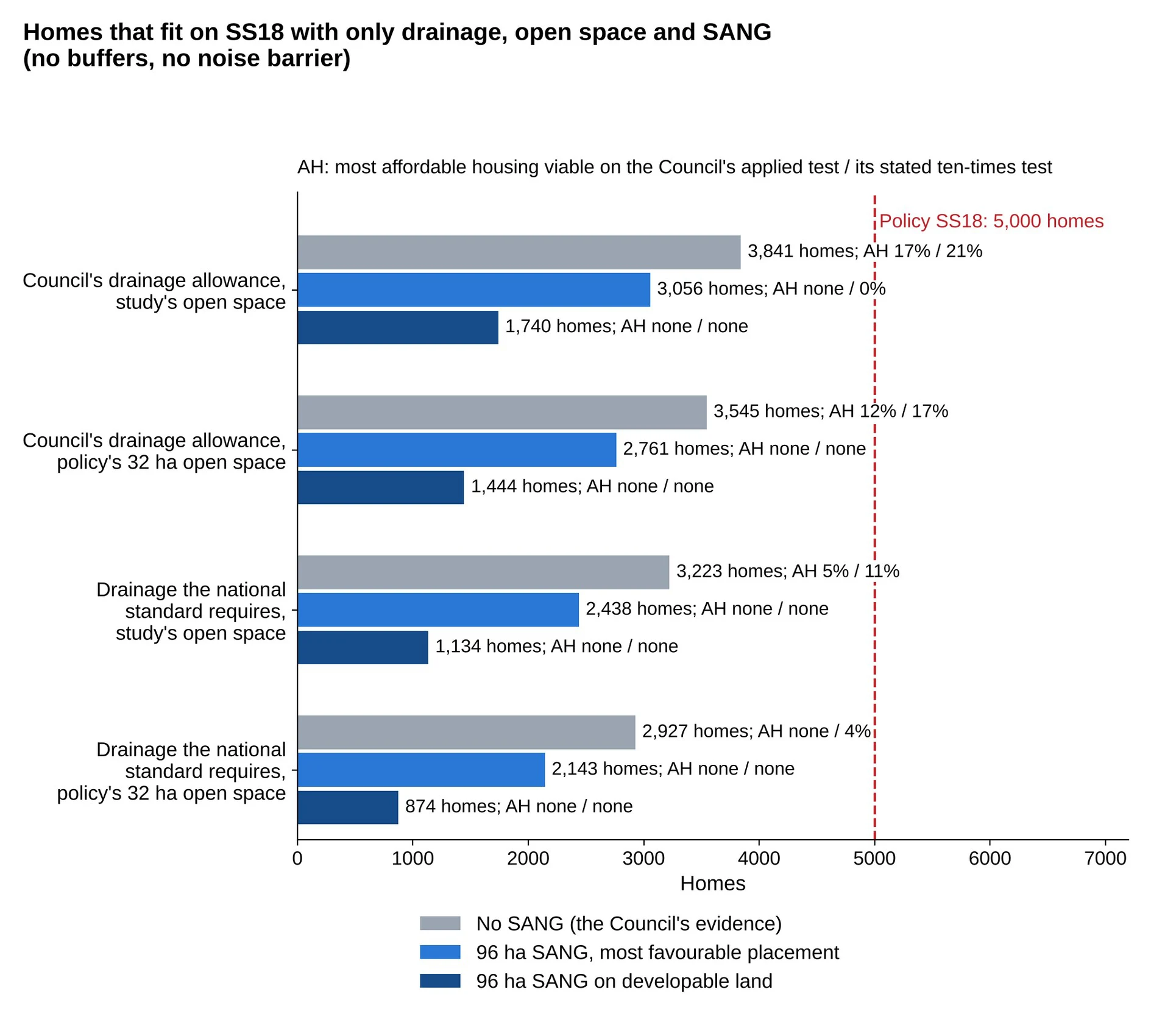
3.6 Even with no SANG at all, the Council’s own capacity carries half the plan’s affordable housing. On the Council’s own capacity of 3,841 homes, the Council’s own appraisals support 17 per cent affordable housing, against the plan’s 35 per cent [1, section 5.2]. With the drainage our model shows is needed, and still no SANG, about 3,000 to 3,200 homes fit and at most 5 per cent affordable housing is viable.
3.7 The filed land budget was the conservative case. It credited the capacity study’s open space towards the SANG, because when we filed we did not know whether Natural England would count ordinary open space as SANG, and we gave the Council the benefit of the doubt. Natural England has since described the policy’s 32 hectares of open space as provided “alongside” the SANG, and asked for at least 96 hectares of SANG [6, page 13]. The position is therefore worse for the council than we originally stated in our main representation.
3.8 No SANG cost appears anywhere in the Council’s evidence. The IDP schedule lists “Suitable Alternative Natural Green Space (SANGS) for Lower Langdon” with no cost [10]. The Viability Assessment contains no SANG cost [11]. Our figures cost SANG at about £291,000 to £381,000 a hectare, including 80 years of management, the same 80-year “lifetime of the development” that the revised Essex Coast RAMS uses [12].
3.9 The RAMS tariff in the Council’s evidence is out of date. The revised Essex Coast RAMS, prepared with Thurrock as a partner authority and endorsed by the Essex planning officers on 30 April 2026, sets a tariff of £476 per dwelling, because the original package “was not costed in perpetuity i.e. it did not consider the lifetime of the development, calculated as 80-years”; Chelmsford City Council applies it from 1 August 2026 [12, pages 1 and 6 to 7]. The IDP uses a “tariff of £159.66 per dwelling” [10, page 165] and the Viability Assessment £175.55 [11]. We have not established whether Thurrock has adopted the £476 rate. The effect on viability is small (about £1.5 million for 5,000 homes) but it is a further input in evidence the Council says has “no further issues” (section 9).
3.10 Why it matters. The policy cannot be delivered as written. Natural England’s requirement for legal compliance cannot be met on the land without removing most of the homes and all of the affordable housing. That engages the tests of effectiveness and justification, and the legal compliance ground in section 2.
4. The allocation was not consulted on with the bodies that matter
4.1 Every environmental, heritage and highway body asked says it was not consulted on Policy SS18 before publication; the only body told of the allocation was the NHS (section 4.2). Their replies to our requests under the Environmental Information Regulations say so in their own words.
- Natural England: “Natural England holds no records of any engagement in scope of this request” (duty to cooperate engagement since 1 January 2023) [13, page 3]. On any request for its opinion under regulation 105(2) on the appropriate assessment, “Natural England holds no additional information other than comments made in our responses to Local Plan consultations” [13, page 2].
- Historic England: “we have not identified any record of consultation with Historic England specifically on allocation SS18 prior to its inclusion in the Regulation 19 Plan” [14].
- National Highways: “There has been no site-specific consultation between National Highways and Thurrock Council” on the allocation [15].
- Environment Agency: no record of consultation on the SS18 allocation before its inclusion in the Regulation 19 plan; its only written advice since January 2023 is its Regulation 18 response of February 2024 [16, page 6].
- Essex County Council, the highway authority for the roads the allocation’s northern access options join: “To date there has been no contact by TC as highway authority to ECC as highway authority on these locations” [17, page 2].
- Network Rail: one invitation to a 45-minute online infrastructure workshop in November 2025, which does not mention the site [18].
- Anglian Water: data supplied to the Council’s Water Cycle Study consultants and two general online meetings (3 December 2025 and 6 May 2026), with “no available meeting notes”, and no capacity confirmation for Policy SS18 [19; 20].
4.2 The Council did engage the NHS, and the NHS says it has no money for the site. On 11 March 2026 the Council told the ICB that “the council’s Leadership team has agreed” to develop an “Option B” plan with a “New allocation at Lower Langdon (approximately 4,000 homes)” [21]. The ICB states: “The ICB does not have a capital allocation for this development” and “The ICB is not funded to construct new buildings” [21]. The IDP nonetheless funds the Lower Langdon health facility from “Developer Contributions + ICB” [10].
4.3 Why it matters: the duty to cooperate and all four tests of soundness. The duty to cooperate (section 33A of the Planning and Compulsory Purchase Act 2004) requires constructive, active and ongoing engagement on strategic matters with the prescribed bodies, which include Natural England, the Environment Agency, Historic England, National Highways and the county highway authority. For Policy SS18 that engagement has not taken place. Deleting Policy SS18 removes the problem; retaining it carries the failure into the examination. The same failure breaks each test of soundness. The policy is not positively prepared, because no agreement with neighbouring authorities on its cross-boundary effects exists. It is not justified, because the evidence these bodies would have provided does not exist. It is not effective, because there is no evidence of joint working on cross-boundary strategic matters and a statement of common ground on Policy SS18 would have to be written from nothing. And it is not consistent with national policy, which requires all three. No body has been asked to consider Policy SS18 together with West Horndon (Policy SS17), Dunton Hills in Brentwood or the Dunton Road application in Basildon (26/00296/OUT), all of which bear on Langdon Ridge SSSI. That is the in-combination assessment Natural England says is unclear [6, page 4].
5. The assessments the allocation needs do not exist
5.1 No assessment of Langdon Ridge SSSI exists. This is required under SSSI law, separately from the HRA. Natural England asked for it in February 2024 and again in October 2026 (section 3.2). It holds “no information regarding any S28I notice from Thurrock Council or any record of the Council’s consideration of its duty under S28G” (the Council’s statutory duties towards SSSIs), and “There have not been any further condition assessments since 2018” [13, page 2]. The Council’s own Detailed Water Cycle Study lists Langdon Ridge SSSI among the sites with “a material dependency on water” and records “Recreational Disturbance (Active pressure with medium risk)” there [4, pages 13 and 16].
5.2 No wintering bird survey of the land exists, so the HRA cannot assess functionally linked land. Natural England asks for multi-season surveys of functionally linked land in each relevant allocation policy [6, page 4]. The HRA itself records Natural England’s advice that, for golden plover and lapwing, land up to 15 km from a protected site may need to be considered as functionally linked [3, page 53]. Residents’ records on and beside the site include golden plover, lapwing and curlew [1, Appendix D].
5.3 No local flood modelling exists. The Environment Agency states that the flood zones within the SS18 boundary “are a combination of local detailed modelling (Stanford 2016 model) and national modelling (New National model)” [16, page 2]. Its letter of 27 October 2026 confirms that the Level 2 SFRA relied on national modelling for the site and that the SFRA itself recommends detailed local modelling of the watercourses [22]. None has been done aside from that in our primary representation.
5.4 The sewer connection was never verified, so the HRA cannot assess the sewage pathway. Anglian Water’s 2023 assessment found that its model’s “verifications in general were poor” and scoped a 30-week programme of flow surveys and model re-verification [20]. Nothing disclosed shows that programme was carried out. We asked Anglian Water on 4 November 2026; its reply is due on 2 December.
5.5 No road junction assessment exists. National Highways: “In connection with the Thurrock Local Plan, we have not carried out specific assessments of these junctions” [15]. Essex County Council has not been asked to assess the effect on its roads [17].
5.6 The capacity study was written to a target. The Council’s site assessment for Lower Langdon records that it “must demonstrate capacity exceeding the 4,000-dwelling target” [23, page 24].
5.7 Why it matters. The wintering bird survey, the sewage and river pathways and the in-combination assessment are all matters an appropriate assessment must address; without them the HRA cannot conclude that the plan will not harm the integrity of the SPA and Ramsar site, and the plan is not legally compliant. The SSSI assessment is required by the Council’s duty under section 28G of the Wildlife and Countryside Act 1981. National policy requires plans to be based on proportionate evidence; for an allocation of 5,000 homes beside an SSSI and within the zone of influence of an internationally protected site, the absence of every site-specific assessment means the policy is not justified and not effective.
6. Public bodies’ statements contradict the policy
6.1 Anglian Water’s own model predicted sewer flooding downstream of the site in an ordinary storm. In 2023 consulting engineers for the land promoter opened a pre-development enquiry with Anglian Water, reference PPE-0160028, for “New development for 4000 C3 dwellings is proposed in land north of Stanford-le-Hope bypass” [20]. Anglian Water’s reply of 30 June 2023 states: “The proposed connection point is at … a 300mm dia combined sewer and the preliminary connection method proposed was by pumping”; “Quick model assessment running a 5 year design storm produced a large volume of flooding predicted at manhole … located downstream of the connection point”; and its estimate assumed several connection options “due to the current predicted flooding between the proposed point of connection and the A13” [20]. Sewer locations are omitted here because Anglian Water has asked that its data not be published. A combined sewer carries rainwater and sewage together, so more sewage in a sewer that already floods in a 5-year storm means more flooding and more spills.
6.2 The Council’s own flood study names Stanford-le-Hope as at risk. The Level 2 SFRA site sheet for Lower Langdon says the site, its access routes and Stanford-le-Hope are at “significant risk of surface water flooding” and that emergency planners should be consulted “prior to allocation” [24, page 8]. No record shows they were. The same sheet tells developers to keep a buffer “alongside the River Mardyke” [24, page 6], a river about 10 km away, which suggests text copied from another site.
6.3 Anglian Water and the Environment Agency both record downstream flood risk. Anglian Water’s Regulation 18 comments on Lower Langdon noted “consequential flood impacts on Stanford-le-Hope” [19]. The Environment Agency asks for Policy SS18 to require that built development “will avoid being placed in Flood Zone 3a and Flood Zone 2 and will not reduce the capacity of the floodplain to store floodwater, whilst seeking opportunities to reduce existing downstream flood risk” [25, pages 15 to 16]. On the Level 2 SFRA’s figures for the site, 7.61 per cent is functional floodplain (Flood Zone 3b), 3.13 per cent Flood Zone 3a and 5.29 per cent Flood Zone 2, and 17.14 per cent is in future fluvial flood zones [22].
6.4 The Council’s water study contradicts itself on water supply. It records “a shortfall of 6,011 dwellings” between the water company’s plan and the Local Plan, and says the water company’s plan cannot “be relied upon as evidence that water supply to meet domestic supply is planned for in the long-term” [4, page 30]. Seventeen pages later it says a long-term “plan is in place to manage the scale of growth proposed within the Local Plan across this WRZ” [4, page 47]. The Environment Agency finds Policy DMP03 unsound on water resources [25, page 1].
6.5 Tilbury WRC cannot take the growth on the study’s own figures. The study’s Table C1 shows Tilbury’s flow after growth at 40,390 cubic metres a day against a permitted 40,000, a shortfall of 390 [4, page 63]. On the study’s own flow per home, that is about 950 homes; the plan’s trajectory places 3,400 of Policy SS18’s homes within the plan period. This is our calculation from the study’s figures.
6.6 The IDP presents an unagreed rail scheme as committed, and rail capacity has not been tested for the allocation. The IDP lists the Stanford-le-Hope station scheme under “Future committed rail improvements” [10, page 39]. Network Rail states that “the scope of the project has yet to be fully agreed with Thurrock council” [18, page 4]. When we asked Network Rail for any capacity assessment that takes account of the Local Plan’s growth, it referred us to its Essex Thameside Strategic Advice (October 2025) [18]. That study assumes Thurrock will build 1,066 homes a year, the target under the method the Government set in summer 2024 [26, page 18], against the 1,444 a year that the Council’s chosen figure of 28,880 homes over 20 years requires. It does not mention Lower Langdon or the Stanford-le-Hope station scheme. Even on its lower figure, it finds that “all seats will be taken” on three morning peak services via Laindon “by 2027” [26, page 38], and that the line via Purfleet, which serves Stanford-le-Hope, will need a further train an hour by 2050 [26, page 40]. No assessment of rail capacity for the allocation has been disclosed.
6.7 The Council’s own site evidence rejected this land. The Stage 2 Green Belt Assessment found that sub-area CS-01 “performs strongly against the NPPF purposes and makes an important contribution to the wider” Green Belt, and it is “Not recommended for further consideration in isolation” [27, page 6]. The Housing Land Availability Assessment classed Corringham Park Farm (site 60893) “Unsuitable - Proximity to settlement” [9, page 7].
6.8 Why it matters. None of these bodies was consulted by the Council on Policy SS18 (section 4). When asked, their own records show the site does not work: it adds to flooding downstream, its sewage works is full, and its health and rail infrastructure is neither funded nor agreed. The policy is therefore not justified (the evidence contradicts it), not effective (it cannot be delivered as written) and not consistent with national policy, which steers development away from areas at risk of flooding and requires the infrastructure a plan relies on to be identified and deliverable.
7. How the replacement HRA and the extension were handled
7.1 The replacement HRA was published without version control and with no statement of what had changed. It has no new version number, no October date and no record of changes. The Council’s Regulation 19 page says only that “an updated version … has been published, following identification of an error in the previously published document” [28]. On 21 October 2026 we asked five written questions: what the error was, what had changed, who had been notified, whether Natural England had been consulted on the replacement, and whether it had been placed in the libraries. The Council’s full answer was: “Unfortunately, a site assessment was omitted in the previous Habitats Regulations Assessment (HRA) document. The site assessment had been undertaken previously; there was simply an administrative error in uploading an incorrect document” [2]. That answer did not say which site assessment had been omitted, and the other four questions were not answered. We asked again on 23 October for the Council to “identify the exact wording changes”; there was no answer [2].
7.2 A second resident asked four times and was not told either. Between them, two residents asked in writing six times between 21 October and 3 November 2026. [The second resident] asked the Council on 21 October 2026 to upload the new version “with the changes noted on the version control page”. The Council’s Planning Policy and Implementation Manager replied on 22 October that the uploaded version “is the correct one” and that “A document version table setting out the appropriate version/date is included I note”. [The second resident] asked again twice on 26 October, first for “a new version number, October date, and a summary of the changes” and then “are you going to update the document as I have requested, so that the changes can be seen and then commented on?”, and on 3 November asked for the matter to be escalated: “What is the point of extending the consultation period, if the document issued can not be used , as it’s impossible to workout (its 324 pages) , what’s changed”. The Council’s only further reply, sent between his two emails of 26 October, asked him to send comments by 10 November; his second email of 26 October and his email of 3 November have had no reply [29]. This is a failure of transparency: the information residents needed to comment on the replacement HRA was asked for six times and was not given.
7.3 The version table in the replacement was changed without saying so. Page 2 of the original HRA dates the final report 3 July 2026 and says the revised Local Plan was “received May 2026”. Page 2 of the replacement dates the final report 7 July 2026 and says the revised Local Plan was “received on 26 May 2026” [30; 3]. Neither records an October version. So two different documents, each called “Final report”, exist, and the replacement’s history was altered without any note. The October file was created at 12:34 on 20 October 2026, a minute before it was uploaded.
7.4 The consultants received a revised plan after Lower Langdon was added, and the July HRA still did not assess it. The Council’s “Option B” decision to add Lower Langdon was taken on or before 11 March 2026 [21]. The HRA consultants received a revised Local Plan in May 2026 [30; 3]. The HRA dated 3 July 2026 still numbered West Horndon as SS18 and did not mention Lower Langdon. We ask the Council to publish which version of the plan its consultants received in May, and the emails transmitting each final report.
7.5 The statutory statement still gives the original closing date. The Statement of Representations Procedure published on the Council’s website, unchanged since 15 September 2026, still says: “The consultation period runs from Wednesday 2nd September to midnight on Wednesday 14th October 2026” and “Late representations may not be accepted” [28]. The Council’s news item “Final chance to have your say on Thurrock’s Local Plan” (6 October 2026) still gives 14 October. No news item about the extension appears on the Council’s website. The first notification to respondents was sent at 18:26 on 23 October 2026, three days after the replacement was published, and only to people who had already responded, and only after we had asked the Council in writing on 21 October who had been notified. As of 9 November 2026 we have received no acknowledgement of our representation of 14 October or confirmation that it has been duly made, although the Council’s notification of 23 October said this would follow [2].
7.6 The Council has not disclosed how Policy SS18 was reinstated, or who promotes it. On 10 September 2026 we asked the Council, under the Environmental Information Regulations, for ten documents already identified in its own published evidence, including the record of the decision to reinstate the allocation and the site promoter’s “demonstration” of deliverability on which the Integrated Impact Assessment says the site was brought back [1, section 3.2] (request FOI/4949). The reply was due by 8 October 2026 under regulation 5(2). None of the information has been provided, and the internal review of the failure to respond, which the Council logged on 12 October, has produced no outcome. A further request of 19 September (FOI/5012), which asks among other things for the identity of the site promoter, was due by 19 October and has not been answered [2]. The only promoter identified in any disclosure appears in Anglian Water’s: its 2023 pre-development enquiry for 4,000 homes on this land was made by consulting engineers, with two addresses at gladman.co.uk (Gladman, a land promoter) copied throughout [20]. Residents cannot test why the allocation was reinstated while the record of that decision is withheld. We ask the Inspector to require the Council to disclose this information before the hearings.
7.7 Why it matters. In our view, regulation 19 requires the Council to publish the proposed submission documents and a statement of the representations procedure, and regulation 20 makes the date in that statement the deadline. Residents were given 21 days to compare two 324-page documents side by side, with no version control, no list of changes, no answer to repeated requests for one, and a statutory statement giving a date that had passed. That is not a fair opportunity to comment on the document the extension was granted for. The Minister’s direction of 23 October 2026 gives the Council until 31 March 2027 to submit, provided its final Regulation 19 period ends by 31 December 2026 [31]. The Council can therefore still cure this by publishing a corrected HRA, a list of changes and a fresh statement of the representations procedure, with six weeks for comment starting by about 19 November 2026. We ask it to do so if Policy SS18 is retained.
8. Corrections to our filed representation
8.1 We correct our own errors first, so that the rest can be relied on. None of these corrections changes a conclusion of the filed representation; the corrections at 8.4, 8.5 and 8.7 strengthen them.
8.2 The Detailed Water Cycle Study exists. Section 4.6, Appendix K and reference [43] of our representation say the detailed Water Cycle Study “has never been produced” and “has not been published”. The Thurrock Detailed Water Cycle Study (AECOM, revision P02 Final, 26 June 2026) is on the Council’s technical evidence page [4]. Our statement relied on Anglian Water’s reply of 12 October 2026, which said it “does not appear to be published” [19]. We withdraw it. The study’s findings are used in sections 2 and 6 above.
8.3 The water company figure is 23,600 homes, not 19,460. Sections 5.3, 5.5, 8.6, Appendix F (F137) and Appendix K of our representation say Essex & Suffolk Water planned for 19,460 homes in Thurrock and that the plan exceeds this by 5,946. The Detailed Water Cycle Study puts the water company’s assumption at about 23,600 homes to 2044 against the plan’s 29,611: “a shortfall of 6,011 dwellings” [4, page 30]. The size of the gap is almost unchanged; the conclusion is now the Council’s own consultants’.
8.4 Ground L1 is restated against the replacement HRA. Our statement that Policy SS18 “is not assessed under any number” was true of the HRA as published in August. Section 2 above restates the ground against the replacement.
8.5 Anglian Water did receive a pre-development enquiry for this land, in 2023. Section 3.1 and section 5.3 of our representation say Anglian Water has made no capacity check, pre-development assessment or connection assessment for Policy SS18. That followed Anglian Water’s own reply of 12 October 2026, which identified none [19]. Its reply of 3 November 2026 disclosed enquiry PPE-0160028 (April to June 2023) [20]. The correct position is in sections 5.4 and 6.1 above: an enquiry was opened; Anglian Water’s model predicted flooding downstream; it scoped a verification study; nothing shows that study was done; no capacity confirmation exists.
8.6 The Level 2 SFRA site sheets were published during the consultation. Section 4.6 and Appendix O of our representation say the Level 2 SFRA’s site proformas are unpublished. They were added to the Council’s evidence page on 29 September 2026, 27 days into the consultation, without notice. The site sheet for Lower Langdon confirms our flood figures and adds the points in section 6.2 above [24].
8.7 The land budget is superseded by section 3. Section 4.4 of our representation ends at 2,126 homes. Section 3 above replaces that with Natural England’s stated requirement and a run with no buffers.
8.8 Network Rail was invited to one workshop. Section 3.5 of our representation says no published record shows engagement with Network Rail. That remains true of the published record, but Network Rail’s reply discloses an invitation to an online infrastructure workshop in November 2025 [18]. An invitation is not engagement on capacity: nothing disclosed shows attendance, site figures or advice.
9. The Council’s statement that “no further issues have been identified”
9.1 The Council told the press on 20 October 2026 that its other documents had been reviewed and found sound. Its statement reads: “Officers have reviewed the remaining consultation documents and can confirm that no further issues have been identified” [32]. The evidence base runs to about 8,600 pages across 57 documents. The statement was made on the day the HRA was replaced, when the Council had held our representation, which lists 162 defects [1, Appendix F], for six days. No review of 8,600 pages could have been completed in that time, still less one able to conclude that there were no further issues. The statement also means one of two things: either the Council had not considered our representation, or it had considered it and decided that none of the 162 defects it identifies is an issue. Either way, the statement cannot be relied on.
9.2 The following errors in the Council’s own documents have been identified since, each set out above:
- The Detailed Water Cycle Study contradicts itself on water supply (6.4).
- The Detailed Water Cycle Study’s assessment of Pitsea WRC copies text from its assessment of Tilbury.
- The Detailed Water Cycle Study uses two different plan totals, 30,471 and 29,611 homes [25, page 17].
- The Environment Agency finds Policy DMP03 unsound (6.4).
- The replacement HRA still relies on Southern Water, which does not serve Thurrock (2.5).
- The replacement HRA screens out a sewage pathway that the Council’s own study says is connected (2.3).
- The replacement HRA’s version history was altered without a note (7.3).
- The IDP presents an unagreed rail scheme as committed (6.6).
- The IDP funds health infrastructure from an ICB that says it has no capital for the site (4.2).
- The IDP and the Viability Assessment use superseded RAMS tariffs (3.9).
- Neither the IDP nor the Viability Assessment costs the SANG on which the policy depends (3.8).
- The Level 2 SFRA site sheet for Lower Langdon refers to the River Mardyke, 10 km away (6.2).
- Allocations NS30, NS31 and NS64 were not assessed in the Level 2 SFRA [25, pages 8, 9 and 14].
- The Level 2 SFRA appendices were added to the evidence base 27 days into the consultation without notice (8.6).
10. What we ask
10.1 Delete Policy SS18 before submission. The plan’s own figures show the Government’s minimum is met without it. The plan states: “Under the Government’s Standard Method (calculated March 2026), Thurrock’s housing requirement is 21,480 homes over the plan period” [33, page 34]. Table 2 of the plan identifies 35,906 homes, 25,406 within the plan period, of which Policy SS18 contributes 3,400 within the period and 1,600 after 2044 [33]. Without it the plan still identifies 30,906 homes, 22,006 within the period. The Council’s chosen figure of 28,880 is not met within the period either with Policy SS18 (25,406) or without it; our representation sets out how that shortfall should be dealt with [1, section 8, MM8].
10.2 The deadline the Cabinet relied on has gone. The Cabinet report of 26 August 2026 said the submission deadline of 31 December 2026 “is firm and cannot be changed” [34]. The Minister’s direction of 23 October 2026 moves it to 31 March 2027 for plans whose final Regulation 19 period ends by 31 December 2026 [31]. There is time to remove an allocation that its own statutory consultee says is not legally compliant.
10.3 If the Council retains Policy SS18, it should before submission: carry out an appropriate assessment of Policy SS18, including the sewage pathway to the Thames Estuary and Marshes SPA and Ramsar site; seek Natural England’s opinion on it under regulation 105(2); carry out the assessment of Langdon Ridge SSSI that Natural England has asked for twice; publish a corrected HRA with a list of changes and a fresh statement of the representations procedure; and allow six weeks for comment.
10.4 Protect Langdon, represented by me, Dr Jackie Lighten, wishes to take part in the hearing sessions of the Examination on Policy SS18, the HRA and the duty to cooperate.
References
- Protect Langdon, Representation on Policy SS18, Volumes 1 and 2, filed 14 October 2026
https://www.protectlangdon.co.uk/representation/ - Thurrock Council, emails to Protect Langdon of 14 October (FOI 4949), 21 October and 23 October 2026; acknowledgements of requests FOI/4949 (10 September and 12 October 2026) and FOI/5012 (19 September 2026)
Annex A, item A9, which includes the acknowledgements. - LUC for Thurrock Council, Habitats Regulations Assessment, July 2026 (version published 20 October 2026)
https://www.thurrock.gov.uk/sites/default/files/2026-10/Thurrock%20Borough%20Local%20Plan%20Habitats%20Regulations%20Assessment%20-%20July%202026_1.pdf - AECOM for Thurrock Council, Thurrock Detailed Water Cycle Study, revision P02, 26 June 2026
https://www.thurrock.gov.uk/sites/default/files/2026-07/Thurrock%20Detailed%20Water%20Cycle%20Study%2C%20June%202026.pdf - Environment Agency, Statutory Main River Map
https://environment.data.gov.uk/arcgis/rest/services/EA/StatutoryMainRiverMap/FeatureServer/0 - Natural England, Regulation 19 response to the Thurrock Local Plan, ref 557779, 14 October 2026
Held by the Council; copy available from Protect Langdon. - Natural England, Regulation 18 response to the Thurrock Local Plan, 19 February 2024, refs 461196 and 461201
Released to Protect Langdon under EIR2026/11807. - Protect Langdon, land budget re-runs with Natural England’s SANG requirement, 6 November 2026
Method, inputs and full results available from Protect Langdon. - Thurrock Council, Housing Land Availability Assessment, Appendices 2 to 4, October 2025
https://www.thurrock.gov.uk/sites/default/files/2026-08/Thurrock%20Housing%20Land%20Availability%20Assessment%20-%20Appendices%202%20-%204%20Site%20Assessments%2C%20October%202025.pdf - Arup for Thurrock Council, Infrastructure Delivery Plan and Schedule, July 2026
https://www.thurrock.gov.uk/sites/default/files/2026-08/Thurrock%20Infrastructure%20Delivery%20Plan%2C%20July%202026.pdf - AspinallVerdi for Thurrock Council, Thurrock Local Plan and CIL Viability Assessment, June 2026
https://www.thurrock.gov.uk/sites/default/files/2026-07/Thurrock%20Local%20Plan%20and%20CIL%20Viability%20Assessment%2C%20June%202026.pdf - Chelmsford City Council, Cabinet 14 July 2026, item 9.1, Adoption of the Revised Essex Coast RAMS
https://www.chelmsford.gov.uk/media/taml1kbj/91-adoption-of-the-revised-essex-coast-recreational-disturbance-and-avoidance-mitigation-strategy-rams.pdf - Natural England, response to request EIR2026/11807, 5 October 2026
Annex A, item A1. - Historic England, response to request 26/04253, 5 October 2026
Annex A, item A2. - National Highways, response to Protect Langdon, reference 27759, 8 October 2026
Annex A, item A3. - Environment Agency, response to request EIR2026/46894, 9 October 2026
Annex A, item A4. - Essex County Council, response to request ECC21200921 09 26, 14 October 2026
Annex A, item A5; also at https://secureapps.essex.gov.uk/Freedom_of_information/ResultDetails.aspx? ID=47118 - Network Rail, response to request FOI2026/01834, 15 October 2026
Annex A, item A6. - Anglian Water, response to request 2522, 12 October 2026
Annex B, item B1 (confidential: not for publication, at Anglian Water’s request). - Anglian Water, response to request 2581, 3 November 2026, with pre-development enquiry PPE-0160028 (April to June 2023)
Annex B, items B2 and B3 (confidential: not for publication, at Anglian Water’s request). - NHS Essex Integrated Care Board, response to request FOI 2627284, 19 October 2026, with the Council’s email of 11 March 2026
Released under the Open Government Licence. Annex A, item A7. - Environment Agency, letters to Protect Langdon of 16 and 27 October 2026, ref 260916/DJ01
Annex A, item A8. - Thurrock Council, Transport Assessment, Lower Langdon Site Specific Assessment, August 2026
https://www.thurrock.gov.uk/sites/default/files/2026-08/Transport%20Assessment%20-%20Lower%20Langdon%20Site%20Specific%20Assessment%2C%20August%202026.pdf - AECOM for Thurrock Council, Level 2 Strategic Flood Risk Assessment, Appendix B, Residential Sites Proforma (published 29 September 2026)
https://www.thurrock.gov.uk/sites/default/files/2026-09/Thurrock%20Level%202%20Strategic%20Flood%20Risk%20Assessment%20-%20Appendix%20B%20-%20Residential%20Sites%20Proforma.pdf - Environment Agency, Regulation 19 response to the Thurrock Local Plan, ref AE/2026/131362/CS-01/SB1, 13 October 2026
Held by the Council; copy available from Protect Langdon. - Network Rail, Essex Thameside Strategic Advice, October 2025
https://sacuksprodnrdigital0001.blob.core.windows.net/long-term-planning/Eastern%20region/Eastern%20region%20-%20planning%20documents/Essex%20Thameside%20Strategic%20Advice%202025.pdf - Arup for Thurrock Council, Stage 2 Green Belt Assessment, Appendix 4.5, Corringham and Stanford- le-Hope, February 2026
https://www.thurrock.gov.uk/sites/default/files/2026-08/Appendix%204.5%20Corringham%20and%20Stanford-le-Hope%20(2)_0.pdf - Thurrock Council, Local Plan Regulation 19 Consultation web page and Statement of Representations Procedure (captured 21 October and 6 November 2026)
https://www.thurrock.gov.uk/new-local-plan-for-thurrock/local-plan-regulation-19-consultation - [A second resident], emails with Thurrock Council, 21 October to 3 November 2026
Annex A, item A10. - LUC for Thurrock Council, Habitats Regulations Assessment, July 2026 (version published August 2026)
https://www.thurrock.gov.uk/sites/default/files/2026-08/Thurrock%20Local%20Plan%20Habitat%20Regulations%20Assessment%2C%20July%202026.pdf - Rt Hon Matthew Pennycook MP, letter to council leaders on legacy system local plans, 23 October 2026
https://www.gov.uk/government/publications/legacy-system-local-plan-extension-letter-from-the-housing-minister - Thurrock Nub News, “Local plan consultation is extended after mistake”, 20 October 2026
https://thurrock.nub.news/news/local-news/local-plan-consultation-is-extended-after-mistake-312073 - Thurrock Council, Thurrock Local Plan 2024 to 2044, Regulation 19 Publication Version, August 2026
https://thurrock.moderngov.co.uk/documents/s54092/Thurrock%20Local%20Plan%20Reg%2019%20Publication%20Low-Res.pdf - Thurrock Council, Cabinet, 26 August 2026, Thurrock Local Plan 2024 to 2044 Regulation 19 Version
https://thurrock.moderngov.co.uk/documents/s54058/Thurrock%20Local%20Plan%202024-2044%20Regulation%2019%20Version.pdf